In brief
To find a useful halfway point between two places, calculate the route first—not the straight line between the pins. Take half of the total driving time or route distance, inspect the towns and exits around that part of the drive, then add a real candidate stop and recalculate both legs. Choose the place that balances the journey while meeting the actual need: coffee, food, restrooms, an overnight stay, or a fair meeting point.
Decide what “halfway” should mean
The geographic midpoint, the midpoint of the road distance, and the point where driving time is split evenly can all be different places.
A straight line ignores the road network. It may cross water, mountains, private land, or an area with no useful place to stop. Even the midpoint of the driven distance may not split the journey into equal time if one half contains slower roads, city traffic, border crossings, or a difficult mountain section.
Choose the definition that matches the trip:
- Halfway by road distance works when you want to divide the mileage roughly in two.
- Halfway by driving time is usually more useful for splitting a long drive or choosing an overnight town.
- Equal travel time from two origins is the fairer target when two people are meeting in the middle.
- A practical break around halfway matters more than mathematical precision when the goal is food, fuel, restrooms, or a safe pause.
For most road trips, start with driving time. A stop ten minutes before the exact midpoint can be much better than a perfect center point with no safe exit or useful facilities.
A quick method for finding the halfway point
Use this workflow when one driver is traveling from an origin to a destination:
Build the direct driving route
Enter the real start and destination, select the route you expect to use, and record its estimated driving time and distance.
Calculate the rough midpoint
Divide the total time or distance by two. A six-hour drive has a three-hour time midpoint; a 420-mile drive has a 210-mile distance midpoint.
Locate the matching route segment
Follow the route to the town, junction, or highway section that falls around that value. Treat it as a search corridor rather than one exact coordinate.
Search for the place you actually need
Look for a restaurant, coffee shop, rest area, park, hotel, or other useful stop in that corridor.
Add the candidate and recalculate
Compare the complete route with the candidate inserted. Check both legs, the total detour, opening hours, access, and the next fallback.
This produces a practical answer even when the map app does not offer a dedicated “find halfway” button. It also prevents the midpoint from becoming a poor stop simply because the nearest town lies on the wrong side of the highway or requires backtracking.
How to find a halfway point with Google Maps
Google Maps shows estimated travel time for route options and lets you add destinations to a driving route. Its official help also documents searching for places along the route. Use those features to test a midpoint manually.
On a computer
- Open Google Maps and request driving directions between the two places.
- Choose the route you realistically plan to drive, especially when several alternatives appear.
- Note the total estimated time and distance, then divide the chosen measure by two.
- Inspect the route around the matching section and identify nearby towns or exits.
- Search that area for the stop type you need.
- Add the candidate as another destination and compare the revised route.
Google documents that stops can be dragged into a different order. Keep the candidate between the origin and final destination before judging the result.
Check traffic assumptions separately
A route that divides evenly now may not divide evenly at the planned departure time. Google Maps provides current and typical traffic information in supported contexts, while departure-time planning can change the estimated duration of the trip.
For a future drive, use the best available departure-time estimate and still treat it as an estimate. Construction, weather, incidents, queues, and the time spent at the stop can change the day. Recheck the route before leaving rather than treating the first calculation as permanent.
How to find a halfway point with Apple Maps
Apple Maps can display driving routes, estimate travel time for a future departure or arrival, and add or reorder stops. The same route-first method works:
- Enter the start and final destination in Maps.
- Review the available driving routes and choose the one you expect to use.
- Note the route duration and estimate the halfway time.
- Inspect the map around that part of the journey and search for a useful place.
- Add the place as a stop and move it before the final destination if necessary.
- Compare the new total time and route shape before saving the plan.
Apple's documentation notes that predicted traffic can change a future travel-time estimate. That is another reason to search within a corridor around the midpoint instead of depending on a single exact minute or mile marker.
Exact midpoint versus a useful road-trip stop
A calculated midpoint answers “where is the center?” A road-trip stop must answer several more questions:
- Can you enter and leave conveniently from your direction of travel?
- How much time does the complete exit-and-return add?
- Will the place be open when you arrive?
- Does it have the food, restrooms, parking, accessibility, or space you need?
- Is there a fallback farther along the route?
- Does stopping there make the second half of the drive easier or harder?
The midpoint should therefore be a starting area for discovery. For a deeper selection method, use the guide to finding stops along a route without large detours.
If the stop is primarily for driver rest, mathematical balance is secondary to alertness. The guide to planning how often to stop on a road trip explains why a scheduled checkpoint must move earlier whenever the driver needs a safe break.
Finding a fair meeting point for two drivers
When two people start from different places and meet in the middle, do not simply calculate one route from A to B and assume the midpoint is fair.
Instead, compare each person's drive to the same candidate:
- Choose a town near the geographic or route midpoint.
- Calculate driving directions from Person A to the town.
- Calculate driving directions from Person B to the town.
- Compare estimated driving time, not only mileage.
- Move the candidate toward the person with the longer or less predictable journey.
- Repeat until the travel burden is reasonably balanced.
A fair meeting point might not be exactly centered. One person may have a direct highway while the other crosses a city or uses slower roads. Parking, public access, opening hours, and the return journey also matter.
Choose the meeting venue only after the town or corridor is settled. A well-placed town with a venue 25 minutes off the road may be worse than the next town with a café beside the exit.
Example: splitting a six-hour road trip
Suppose a direct route is estimated at six hours and 360 miles. The rough midpoint is three hours or 180 miles, but the two measures point to slightly different areas because the first half includes slower roads.
The three-hour area contains a highway junction with a service plaza. The 180-mile point lies farther along near a small town with a restaurant that requires a 15-minute exit-and-return detour.
Choose based on the purpose:
- For a short restroom and coffee break, the service plaza is the better practical midpoint.
- For a proper meal and a longer reset, the town may justify the detour.
- For an overnight split, neither may be suitable; a larger town before or after the center could offer safer parking and better lodging.
If the break is a public rest area, verify its current status and travel direction using the responsible road authority. The guide to finding rest stops along your route explains how to distinguish official rest areas from commercial service stops and keep a fallback.
Common halfway-point mistakes
Using the straight-line center
The center of two coordinates is not automatically on the road. Use it only to identify the broad region, then return to the actual driving route.
Splitting distance when time is the real concern
Equal mileage can still create unequal driving days. If the goal is rest, arrival timing, or fairness between drivers, compare estimated time.
Ignoring the selected route
Two map routes may pass through different towns. Select the likely route before looking for its midpoint, and recalculate if the route changes.
Choosing a town without testing the venue
Finding the right town is not the same as finding the right stop. Insert the actual restaurant, park, hotel, or rest area and compare the complete route.
Treating the estimate as a promise
Traffic and road conditions change. Use a corridor, keep a fallback, and recheck before departure.
Searching while driving
Plan before leaving or make changes while safely parked. A passenger can help with updates, but the driver should not operate the phone or rebuild the itinerary on the move.
When the halfway stop is still only a description
Sometimes the calculation is easy but the place selection is not. You may know you want “excellent coffee around halfway,” “lunch near water after about three hours,” or “a clean rest stop before the mountain section” without knowing the town or venue.
Ownway is designed for that planning stage. Describe the origin, destination, timing, stop purpose, and acceptable detour; Ownway finds and orders suitable places, then shows the planned drive before handing navigation to Apple Maps, Google Maps, or Waze.
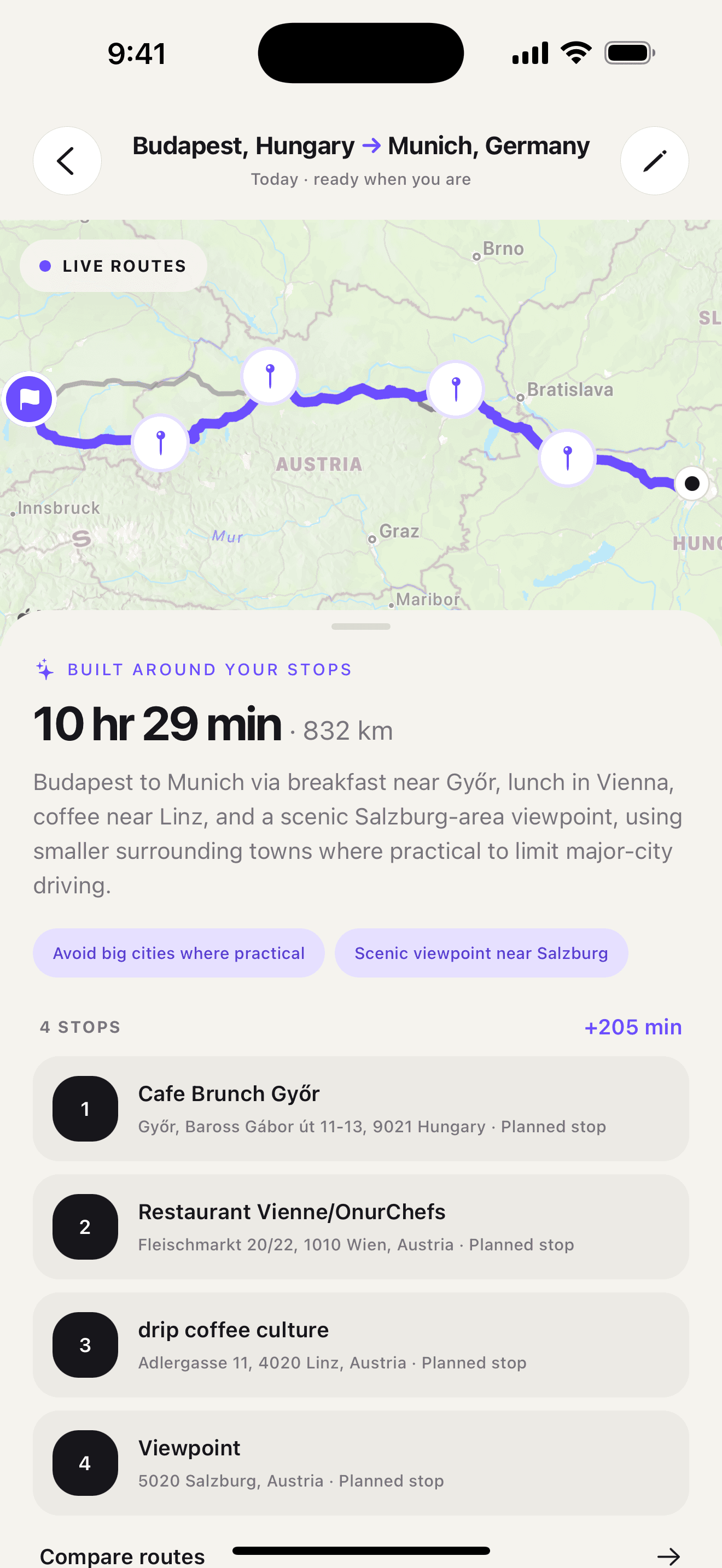
Ownway is not a geometric midpoint calculator, and it does not guarantee that a stop falls on one exact mathematical coordinate. Its useful role is turning a halfway intention into a real place that fits the route and the rest of the trip.
Get Ownway from the App Store or Google Play when the missing answer is the place rather than the arithmetic.
Choose a balanced place, not just a center point
Start with the direct driving route, decide whether time or distance should be split, and search within a corridor around the result. Then test the real stop in the complete itinerary.
That final check turns an abstract midpoint into a useful plan: a place that is reachable, open, appropriate, and worth the detour. Browse the Ownway road-trip blog for more route and stop-planning guides.
Sources
- Get directions and show routes in Google MapsGoogle Maps Help · Accessed November 3, 2026
- Plan your commute or tripGoogle Maps Help · Accessed November 3, 2026
- Change or add stops to your route in Maps on iPhoneApple Support · Accessed November 3, 2026
- Get driving directions in Maps on iPhoneApple Support · Accessed November 3, 2026